DATA2GOHEALTH.NYC
DATA2GOHEALTH.NYC is a free, easy-to-use data tool you can use on your phone or computer. Measure of America created DATA2GOHEALTH.NYC with funding from The Leona M. and Harry B. Helmsley Charitable Trust.
DATA2GOHEALTH.NYC brings together federal, state, and city data on all things health, for all New Yorkers. The website includes over 300 indicators for New York City neighborhoods, and about half of these indicators are available by community district, and almost a quarter by census tract.
DATA2GOHEALTH.NYC builds on DATA2GO.NYC, its sister tool, and provides reliable, up-to-date information on neighborhood assets and challenges across a broader range of health sectors. Health is more than your genetics or the results of your annual physical, and understanding the full spectrum of health determinants is crucial to understanding health outcomes. These two tools are for everyone—to craft effective solutions, target policies and services, advocate for change, and hold elected officials accountable for human progress.
The data come predominantly from public entities, including the US Census Bureau, the New York State Department of Health, and New York City agencies responsible for promoting the well-being of New Yorkers in many areas: health, education, public safety, and more.
The following geographic units are used in the tool:
- NYC
- The five boroughs
- 59 community districts OR 55 public use microdata areas OR 42 United Hospital Fund areas. These are all noted as CDs, PUMAs, or UHF areas.
- 188 neighborhood tabulation areas (NTAs)
- 2,166 census tracts
City- and borough-level data are available for almost all of the indicators in DATA2GOHEALTH.NYC The CD-, UHF-, and NTA-level data primarily come from New York City agencies, particularly the Department of Health and Mental Hygiene. PUMA- and census-tract-level data primarily come from the US Census Bureau.
The default for the tool is to display all data at the smallest available geography. The user can toggle geographies on and off, but we recommend using the default setting of all geographies turned on.
For more detailed information, see the FAQ and tutorial.
***
Measure of America is a nonpartisan research and advocacy initiative of the Social Science Research Council . We breathe life into numbers, providing easy-to-use yet methodologically sound tools for understanding well-being and opportunity in America. We work with partners to measure what matters and believe that everyone deserves the chance to live a freely chosen, flourishing life.
The Helmsley Charitable Trust aspires to improve lives by supporting exceptional efforts in the US and around the world in health and select place-based initiatives.
SUGGESTED ATTRIBUTION:
Measure of America, Social Science Research Council. 2018. DATA2GOHEALTH.NYC. http://www.data2gohealth.nyc.
DATA2GOHEALTH.NYC TEAM
Concept & Project Direction: Kristen Lewis & Becky Ofrane, Measure of America; Rosten Woo
Design: Rosten Woo
Data collection and much more: Rupsha Basu, Lily Canaan, Rebecca Gluskin, Yo Jeremijenko, Laura Laderman, Brianna Noonan, Becky Ofrane, Marina Recio, Abby Tremel, Anne Vierse, and Jamala Wallace.
Application development and coding: Codie Joseph See
Logo and MOA brand identity: Humantific
ADVISORY COMMITTEE
Shoshanah Brown
AIRnyc
Alan Cohen
JASA
Lisa David
Public Health Solutions
Nichola Davis
OneCity Health, NYC Health and Hospitals
Maida Galvez
Mount Sinai Pediatric Environmental Health
Aviva Goldstein
Fund for Public Health NYC
Hannah Gould
NYC Department of Health and Mental Hygiene
Charon Gwynn
NYC Department of Health and Mental Hygiene
Polina Hanin
StartUp Health
Terry Huang
CUNY Graduate School of Public Health and Policy
Andrea Mata
NYC Housing Authority
Denis Nash
CUNY Institute for Implementation Science in Population Health
Remle Newton-Dame
OneCity Health, NYC Health and Hospitals
Sharon Perlman
NYC Department of Health and Mental Hygiene
Charles Platkin
Hunter College Food Policy Center
Laura Pugliese
HITLAB
Asa Radix
Callen-Lorde Community Health Center / NYU
Fernando Tirado
NYC Department of Health and Mental Hygiene
Abbie Watts
Community Food Advocates
Susan Yee
Community Healthcare Network
Pharmacies Ask for Lots of Info to Book a COVID-19 Vaccine. What Happens to That Data?
April 16, 2021 — Consumer Reports
Ensuring Health Data Collection Protects Patient Privacy, Equity
March 30, 2021 — Health IT Analytics
OurHome.NYC
Interactive Tool to Measure Well-Being Among NYCHA Residents
Access the tool here.
OurHome.NYC is a free, easy-to-use online mapping and data tool that depicts the relationship between health, as measured by life expectancy, and housing across more than 300 New York City Housing Authority (NYCHA) developments. NYCHA residents, policymakers, and community-based organizations can view and compare over 150 health-related indicators to make informed decisions, advocate for change, and better understand a development or neighborhood.
OurHome.NYC features life expectancy estimates produced by the U.S. Small-Area Life Expectancy Estimates Project (USALEEP), a partnership of the National Center for Health Statistics, the National Association for Public Health Statistics and Information Systems, and the Robert Wood Johnson Foundation. Measure of America created this tool with support from the Urban Institute, using funds provided by the Robert Wood Johnson Foundation. We thank them for their support but acknowledge that the findings and conclusions presented in this tool are those of the author(s) alone, and do not necessarily reflect the opinions of the Urban Institute or the Robert Wood Johnson Foundation.
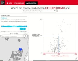
A snapshot of OurHome.NYC, looking at the relationship between life expectancy and education
For more information: contact@measureofamerica.org
How We Reported on Gunshot Victims’ Access to Trauma Care
December 18, 2019 — SOURCE
Highway to Health
 Life Expectancy in Los Angeles County
LAUNCHED OCTOBER 4, 2017 | MEDIA RELEASE
Highway to Health is a preview of the larger Portrait of Los Angeles County human development report, which will be released in late November.
Published in collaboration with the Los Angeles (LA) County Department of Public Health, Highway to Health: Life Expectancy in Los Angeles County reveals up-to-date life expectancy calculations for cities and unincorporated areas within Los Angeles County, the first release of such data in more than a decade. The report examines 106 cities and unincorporated neighborhoods and includes recommendations for increasing life expectancy and reducing disparities.
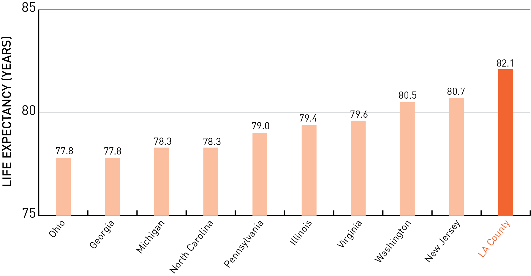
A baby born in Los Angeles County in 2014 can expect to live 82.1 years, several years longer than the average American born that same year, 78.8 years. If LA County were a country, it would rank eleventh in the world in longevity. Los Angeles outperforms all nine states with populations of similar size (in the range of seven to thirteen million residents).
The average LA County resident born in 2000 could expect to live 78.7 years. By 2010, life expectancy had increased to 81.5 years – an improvement of almost three years. Within LA County, life expectancy rates vary by community as much as 14.7 years.
Top-Five Communities in LA County with the Longest Life Expectancies:
- Walnut Park (90.5 years); Malibu (89.8 years); Castaic (88.9 years); Rowland Heights (87.0 years); and Rancho Palos Verdes (86.7 years)
Bottom-Five Communities in LA County with the Shortest Life Expectancies:
- Lancaster (76.4 years); Westmont (76.3 years); Lake Los Angeles (76.2 years); East Rancho Dominguez (76.1 years); and Sun Village (75.8 years)